Canadian Rockies

We left Calgary, BC and headed North into the beautiful
Canadian Rockies!
The Canadian Rockies comprise the Canadian segment of the North American Rocky Mountains. They are the eastern part of the Canadian Cordillera, which is a system of multiple ranges of mountains which runs from the Canadian Prairies to the Pacific Coast. The Canadian Rockies mountain system comprises the southeastern part of this system, laying between the Interior Plains of Alberta and Northeastern British Columbia on the east to the Rocky Mountain Trench of BC on the west. The southern end borders Idaho and Montana of the USA. In geographic terms the boundary is at the Canada/US border, but in geological terms it might be considered to be at Marias Pass in northern Montana. The northern end is at the Liard River in northern British Columbia.
The Canadian Rockies have numerous high peaks and ranges, such as Mount Robson (Sometimes called Mount Bella) (3,954 m (12,972 ft)) and Mount Columbia (3,747 m (12,293 ft)). The Canadian Rockies are composed of shale and limestone. Much of the range is protected by national and provincial parks, several of which collectively comprise a World Heritage Site.
Moraine Lake
This is considered one of the most beautiful stops on our trip through the Canadian Rockies!
Moraine Lake is a glacially-fed lake in Banff National Park, 14 kilometres (8.7 mi) outside the Village of Lake Louise, Alberta, Canada. It is situated in the Valley of the Ten Peaks, at an elevation of approximately 6,183 feet (1,885 m). The lake has a surface area of .5 square kilometres (0.19 sq mi).


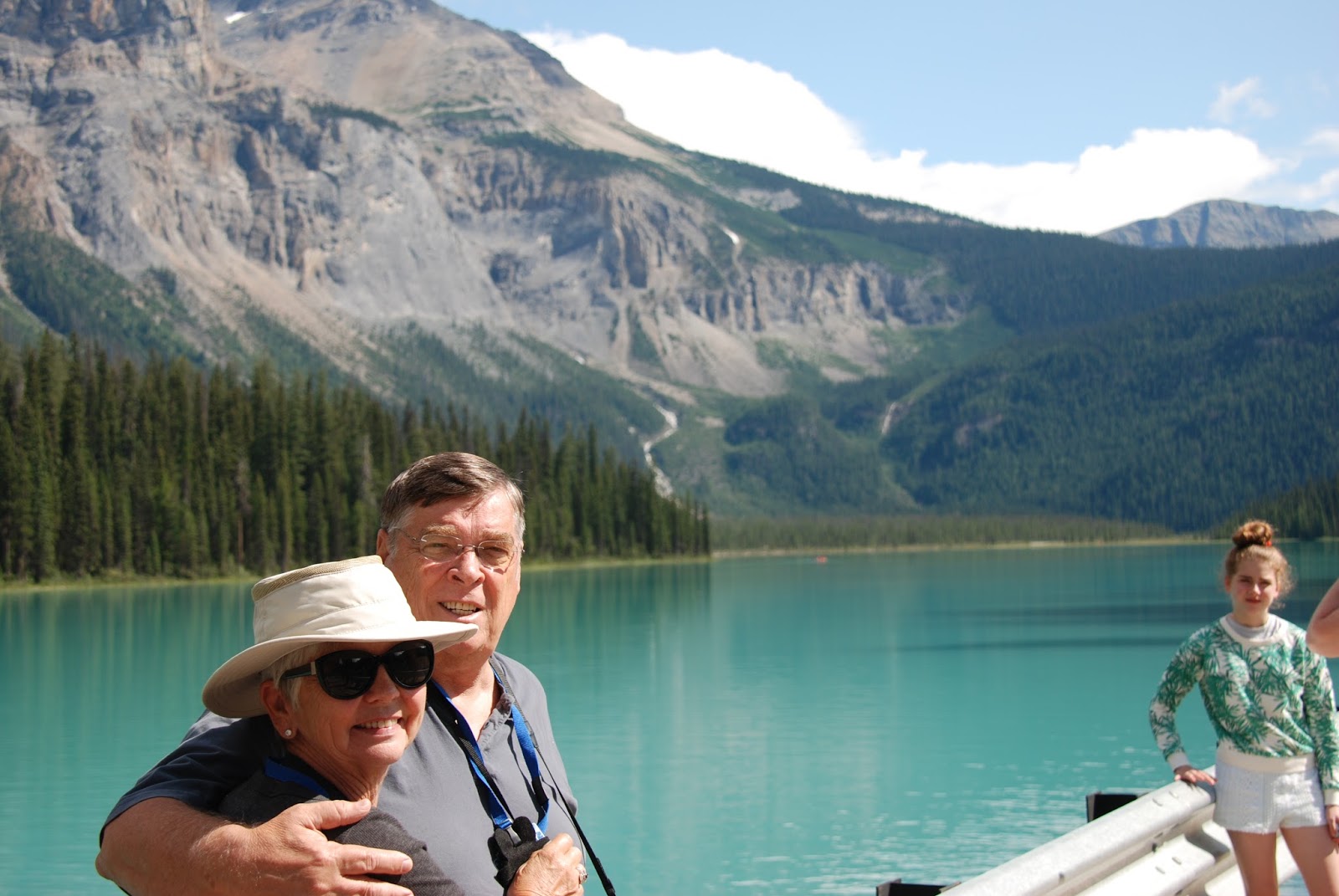
On to Emerald Lake!


Emerald Lake is located in Yoho National Park, British Columbia, Canada.
It is the largest of Yoho's 61 lakes and ponds, as well as one of the
park's premier tourist attractions. Emerald Lake Lodge, a high-end lodge
perched on the edge of the lake, provides local accommodation. A 5.2 km
(3.2 mi) hiking trail circuits the lake, the first half of which is
accessible to wheelchairs and strollers. During the summer months, canoe
rentals are available; in the winter, the lake is a popular cross
country skiing destination.
The lake is enclosed by mountains of the President Range, as well as Mount Burgess and Wapta Mountain.
This basin traps storms, causing frequent rain in summer and heavy
snowfalls in winter. This influx of moisture works with the lake's low
elevation to produce a unique selection of flora. Trees found here are more typical of B.C.'s wet interior forests, such as western red cedar, western yew, western hemlock and western white pine. The alluvial fan on the northeast shore produces wildflowers in abundance during late June and early July.
Due to its high altitude, the lake is frozen from November until
June. The vivid turquoise color of the water, caused by powdered
limestone, is most spectacular in July as the snow melts from the
surrounding mountains.
The first European to set sight on Emerald Lake was guide Tom Wilson,
who stumbled upon it by accident in 1882. A string of his horses had
gotten away, and it was while tracking them that he first entered the
valley. The lake had an impression on even the most seasoned of
explorers: "For a few moments I sat [on] my horse and enjoyed the rare,
peaceful beauty of the scene." It was Wilson who gave the lake its name
because of its remarkable color, caused by fine particles of glacial
sediment, also referred to as rock flour,
suspended in the water. However, this was not the first time Wilson had
dubbed a lake 'Emerald'. Earlier that same year he had discovered
another lake which he had given the same moniker, and the name even
appeared briefly on the official map. This first lake however, was
shortly renamed Lake Louise.


Life Is Good!


Enjoying our day of sight seeing. Next the Spiral Tunnels!
Our bus driver was great. He brought us to the spiral tunnel just in time to witness a train traveling this engineering wonder!
The Big Hill on the Canadian Pacific Railway main line in British Columbia, Canada, was the most difficult piece of railway track on the Canadian Pacific Railway's route.It was situated in the rugged Canadian Rockies west of the Continental Divide and Kicking Horse Pass. Even though the Big Hill was replaced by the Spiral Tunnels in 1909, the area has long been a challenge to the operation of trains and remains so to this day.
The essential problem was that the railway had to ascend 1,070 feet
(330 m) along a distance of 10 miles (16 km) from Field at 4,267 feet
(1,301 m) climbing to the top of the Continental Divide at 5,340 feet
(1,630 m).
The narrow valleys and high mountains limited the space where the
railway could stretch out and limit the grade (hence the later decisions
to bore extra mileage under the mountains and lower the grades)
Construction
To complete the Pacific railway as quickly as possible, a decision
was made to delay blasting a lengthy 1,400 feet (430 m) tunnel through Mount Stephen
and instead build a temporary 8-mile (13 km) line over it. Instead of
the desired 2.2% grade (116 feet to the mile) a steep 4.5% (some sources
say 4.4%) grade was built in 1884. This was one of the steepest railway lines anywhere. It descended from Wapta Lake to the base of Mount Stephen, along the Kicking Horse River to a point just west of Field, then rose again to meet the original route.
Three safety switches were built to protect against runaway trains.
These switches led to short spurs with a sharp reverse upgrade and they
were kept in the uphill position until the operator was satisfied that
the train descending the grade towards him was not out of control. Speed
was restricted to eight miles per hour (13 km/h) for passenger trains
and six (10 km/h) for freight, and elaborate brake testing was required
of trains prior to descending the hill. Nevertheless, disasters occurred
with dismaying frequency.
Field was created solely to accommodate the CPR’s need for additional
locomotives to be added to trains about to tackle the Big Hill. Here a
stone roundhouse with turntable was built at what was first known simply
as Third Siding. In December 1884 the CPR renamed it Field after C.W. Field,
a Chicago businessman who, the company hoped, might invest in the
region after he had visited on a special train they had provided for
him.
The Spiral Tunnels

The old and the new line

The Big Hill "temporary" line was to remain the main line for twenty-five years, until the famous Spiral Tunnels were opened on September 1, 1909.
The improvement project was started in 1906, under the supervision of John Edward Schwitzer,
the senior engineer of CPR’s western lines. The first proposal had been
to extend the length of the climb, and thus reduce the gradient, by
bypassing the town of Field at a higher level, on the south side of the
Kicking Horse river valley. This idea had quickly been abandoned because
of the severe risk of avalanches and landslips on the valley side. Also
under consideration was the extension of the route in a loop
northwards, using both sides of the valley of the Yoho river to increase
the distance, but again the valley sides were found to be prone to
avalanches. It was the experience of severe disruption and delay caused
by avalanches on other parts of the line (such as at the Rogers Pass station, which was destroyed by an avalanche in 1899) that persuaded Schwitzer that the expensive solution of digging spiral tunnels was the only practical way forward.
The route decided upon called for two tunnels driven in three-quarter
circles into the valley walls. The higher tunnel, "number one," was
about one thousand yards in length and ran under Cathedral Mountain,
to the south of the original track. When the new line emerged from this
tunnel it had doubled back, running beneath itself and 50 feet (15 m)
lower. It then descended the valley side in almost the opposite
direction to its previous course before crossing the Kicking Horse River
and entering Mount Ogden
to the north. This lower tunnel, "number two," was a few yards shorter
than "number one" and the descent was again about fifty feet. From the
exit of this tunnel the line continued down the valley in the original
direction, towards Field. The constructions and extra track would
effectively double the length of the climb and reduce the ruling gradient to 2.2%. The new distance between Field and Wapta Lake, where the track levels out, is 11 1⁄2 miles (18.5 km).
The contract was awarded to the Vancouver engineering firm of MacDonnell, Gzowski and Company and work started in 1907. The labor force amounted to about a thousand and the cost was about 1.5 million Canadian dollars.
Even after the opening of the spiral tunnels, Field Hill remained a significant challenge and it was necessary to retain the powerful locomotives at Field locomotive depot.
Everyone gathered to witness and take pictures of the train traversing the spiral tunnel system!

Just sooo much to see!


As We Traveled Trough The Park
There Were Many Sights To Behold!
You've Got To Love This Sign!!

We Saw Lots of Elk!

This is the Ski Lodge Where Lunch Was Waiting For Us
Yum Yum!

This Was No Ordinary Drive!


Furry Little Friend We Met!

Lake Louise
Lake Louise, named Lake of the Little Fishes by the Stoney Nakota First Nations people, is a glacial lake within Banff National Park in Alberta, Canada. It is located 5 km (3.1 mi) west of the Hamlet of Lake Louise and the Trans-Canada Highway (Highway 1).
Lake Louise is named after the Princess Louise Caroline Alberta (1848–1939), the fourth daughter of Queen Victoria and the wife of the Marquess of Lorne, who was the Governor General of Canada from 1878 to 1883.
The emerald color of the water comes from rock flour carried into the lake by melt-water from the glaciers that overlook the lake. The lake has a surface of 0.8 km2 (0.31 sq mi) and is drained through the 3 km long Louise Creek into the Bow River.


Off To Jasper and The Ice Fields!

The Columbia Icefield is located in the Canadian Rockies astride the Continental Divide along the border of British Columbia and Alberta, Canada, the ice field lies partly in the northwestern tip of Banff National Park and partly in the southern end of Jasper National Park.
It is about 325 square kilometres (125 sq mi) in area, 100 metres
(330 ft) to 365 metres (1,198 ft) in depth and receives up to 7 metres
(280 in) of snowfall per year.
Waiting to Board The Terra Buggy!

WELL - Some Of Us Were!!!!


The Terra Buggy is Awesome!
Here is some information about them.
The Terra Bus wheeled vehicle is one of the few snow coach type vehicles currently produced. It is an all-wheel-drive, three axle, off-road bus which is specially constructed for use in Arctic climates by the Canadian specialty vehicle manufacturer Foremost, based in Calgary.
The Terra Bus can transport up to 56 passengers. The vehicle is equipped with six extra-large, low pressure tires - typically filled to 30 pounds per square inch (210,000 Pa). One Modified Terra Bus can be found transporting passengers at the Antarctic research station, McMurdo Station. Twenty-two unmodified Terra Buses can be found at the Columbia Icefield and at Jasper National Park being operated by Brewster Co. for their Ice Explorer tour.
SPECIFICATIONS
| Dimensions | ||
| Height | 13’ | 3.96 m |
| Length | 48’ 10.5” | 14.89 m |
| Width | 11’ 10” | 3.61 m |
| Weight | ||
| Tare | 55,000 lbs. | 24,950 kg |
| G.V.W. | 66,000 lbs. | 29,940 kg |
| Powertrain | ||
| Engine | Detroit Diesel Series, 50 | 2100 rpm |
| 250 HP | 187 kW | |
| Transmission | Clark 34600 Series Power Shift | |
| Suspension | Leaf spring – front; Walking beam – rear | |
| Axles | Rockwell Drive Steer Planetary – front; Rockwell Planetary – rear | |
| Tires | Goodyear Terra tires 66 x 43 x 25 | |
| Brakes | Air over hydraulic drums – front; Air drums – rear | |
| Performance | ||
| Maximum Speed | 25 mph | 50 km |
| Turning Radius | 72 ft | 21.9 m |


Gathering Fresh Glacial Water For A Drink!


The Jasper Skytram is the highest and longest aerial tramway located in Canada. It was built in 1964 and goes to a height of 2,277 m (7,472 ft) above sea level. It is a ten-minute drive from Jasper, Alberta and crests The Whistlers Mountain. It is roughly 230 km north of Lake Louise along the Icefields Parkway (Highway 93).
More Sights Over Looking Jasper!


While At The Whistler Campground - A Heard of Elk Were in The Area!

Lets Continue North - On Towards Alaska!
No comments:
Post a Comment