The Columbia River Gorge!

Another beautiful park location!

The Dalles Dam is a concrete-gravity run-of-the-river dam spanning the Columbia River, two-miles east of the city of The Dalles, Oregon, United States. It joins Wasco County, Oregon with Klickitat County, Washington, 192 miles upriver from the mouth of the Columbia near Astoria, Oregon.The Army Corps of Engineers commenced work on the dam in 1952 and completed it five years later. Slackwater created by the dam submerged Celilo Falls, the economic and cultural hub of Native Americans in the region and the oldest continuously inhabited settlement in North America. On March 10, 1957, hundreds of observers looked on as the rising waters rapidly silenced the falls, submerged fishing platforms, and consumed the village of Celilo.
The reservoir behind the dam is named Lake Celilo and runs 24 miles up the river channel, to the foot of John Day Dam. The dam is operated by the U.S. Army Corps of Engineers (USACE), and the power is marketed by the Bonneville Power Administration (BPA). It is part of an extensive system of dams on the Columbia and Snake Rivers.

This is the Dalles Dam!

Next stop is "Vista House".
The Crown Point Vista House was completed in 1918. It was designed by Edgar M. Lazarus. With its marble interior and brass fixtures, some Oregonians at the time derided it as the "$100,000 Outhouse". The original idea for an observatory at the site came from Samuel Lancaster, the consulting engineer for the Columbia River Highway. Lancaster proposed
"an observatory from which the view both up and down the Columbia could be viewed in silent communion with the infinite"


Some of the ornate stain glass at the observatory!

Lew and Lana enjoying the view of the Columbia River!

Hi from Diana!

Yes - A rose for sure!

Don taught us about how wheat is "drilled" and NOT planted!
Hi Don!
Hi Don!

Hi - back at you Jan!

Even though cloudy and rainy
The view was spectacular!
Next stop along the scenic gorge is--

Too pretty to try to describe!


While having dinner at the "High Country Inn
we had many hummingbirds at the feeders.


Next we visited the Columbia River Gorge
Cascade Locks Region
Cascade Locks Region
Where we took a paddle boat ride on the Columbia River!
Statue of Sacagawea


Lots of beautiful flowers once more!


Our Paddle Wheeler getting ready to pick us up!


On our way!


The Captain - Time to shove off!
Views along the way!

Here comes "Bridge of the Gods!"


Amazing the power!

Native Americans fish along the river for Salmon!


We all are enjoying the magnificent scenery along the way!


We saw seals!

Remnants of the old highway!

Trains carrying cargo!

Beautiful mountain tops!

The actual locks at the Bonneville Dam!
Bonneville Lock and Dam /consists of several run-of-the-river dam structures that together complete a span of the Columbia River between the U.S. states of Oregon and Washington at River Mile 146.1. The dam is located 40 miles east of Portland, Oregon, in the Columbia River Gorge. The primary functions of Bonneville Lock and Dam are electrical power generation and river navigation. The dam was built and is managed by the United States Army Corps of Engineers. Electrical power generated at Bonneville is distributed by the Bonneville Power Administration. Bonneville Lock and Dam is named for Army Capt. Benjamin Bonneville, an early explorer credited with charting much of the Oregon Trail. The Bonneville Dam Historic District was designated a National Historic Landmark District in 1987.In 1896, prior to this damming of the river, the Cascade Locks and Canal were constructed, allowing ships to pass the Cascades Rapids, located several miles upstream of Bonneville.
Prior to the New Deal, development of the Columbia River with flood control, hydroelectricity, navigation and irrigation was deemed as important. In 1929, the US Army Corps of Engineers published the 308 Report that recommended 10 dams on the river but no action was taken until the Franklin D. Roosevelt administration and the New Deal. Now at this time, America was in the Great Depression, and the dam's construction provided jobs and other economic benefits to the Pacific Northwest. Inexpensive hydroelectricity gave rise, in particular, to a strong aluminum industry. During the New Deal and funded from the Public Works Administration, in 1934, two of the larger projects were started, the Grand Coulee Dam and the Bonneville Dam. 3,000 workers in non-stop eight-hour shifts, from the relief or welfare rolls were paid 50-cents an hour for the work on the dam as well as raising local roads for the reservoir.
To create the Bonneville Dam and Lock, The Army Corps of Engineers first built one of the largest scale models in history of the proposed dam, the section of river it was to be located on, and its various components to aid in the study of the construction. First a new lock and a powerhouse was constructed which were on the south (Oregon) side of Bradford Island, and a spillway on the north (Washington) side. Coffer dams had to be built in order to block half of the river and clear a construction site where the foundation could be reached. These projects, part of the Bonneville Dam were completed in 1937.
Both the cascades and the old lock structure were submerged by the Bonneville Reservoir, also known as Lake Bonneville, the reservoir that formed behind the dam. The original navigation lock at Bonneville was opened in 1938 and was, at that time, the largest single-lift lock in the world. Although the dam began to produce hydroelectricity in 1937, Commercial electricity began its transfer from the dam in 1938.
A second powerhouse (and dam structure) was started in 1974 and completed in 1981. The second powerhouse was built by widening the river channel on the Washington side, creating Cascades Island between the new powerhouse and the original spillway. The combined electrical output of the two power houses at Bonneville is now over 1000 megawatts.
Despite its world record size in 1938, Bonneville Lock became the smallest of seven locks built subsequently at different locations upstream on the Columbia and Snake Rivers; eventually a new lock was needed at Bonneville. This new structure was built on the Oregon shore, opening to ship and barge traffic in 1993. The old lock is still present, but is no longer used.
Dimensions and statistics
- Owner: U.S. Army Corps of Engineers, Portland District
- Location: On Columbia River about 40 miles upstream from Portland, Oregon
- First Powerhouse – Constructed in 1933-37; Dam 313 m (1,027 ft) long x 77 feet (23 m) high forebay; 10 generators with a nominal total output capacity of 526.7 MW; Overload capacity 577 MW.
- Spillway – Constructed 1933-37; 18 gates over a length of 442 m (1,450 ft); maintains the reservoir (upriver) usually 18 m (59 ft) above the river on the downstream side;
- Second Powerhouse – Constructed 1974-82; Dam 300.5 m (986 ft) long x 77 feet (23 m) high forebay; 8 generators (plus two at fish ladders) with a nominal total generating capacity of 558.2 MW; Overload capacity 612 MW.
- Bonneville Lock – Constructed from 1987 to 1993 at a cost of $341 million; 26 m (85 ft) wide, 206 m (676 ft) long; transit time is approx. 30 minutes. Replaced earlier smaller lock built 1938.
- Lake Bonneville – 77 km (48 mi) long reservoir on the Columbia River created by Bonneville Dam; part of the Columbia-Snake Inland Waterway.


Lots of fish going through the fish ladder!
 Old Turbine.
It seemed like every place we turned there were always flowers to see!


Next we headed off to see Mt. St Helens!


As we headed up towards Mt. St Helens
You could see evidence of the destructive power everywhere!


On a clear day - Mt. St. Helens is right in front of this giant window.
But it is raining out today - oh well!

Stand outside - it is a little better - but still foggy.


We had a visitor show us clothing from the period.

Jan tries on the Ermine coat.

Jean too!

Jean and Harvey with Harvey modeling a hat and basket with our host.


Joan got into trying on the Ermine and a different hat!

Joan helping Belva with the Ermine coat.
OK
So what is Ermine you ask?
The stoat (Mustela erminea), also known as the short-tailed weasel, is a species of Mustelidae native to Eurasia and North America, distinguished from the least weasel by its larger size and longer tail with a prominent black tip. The name ermine is often, but not always, used for the animal in its pure white winter coat, or the fur thereof. In the late 19th century, stoats were introduced into New Zealand to control rabbits. However the stoats have had a devastating effect on native bird populations (see stoats in New Zealand).
Next we move on to Astoria, Oregon.

Lumber waiting for export abroad.


In Seaside, Oregon we got to visit the Pacific Ocean!


Ivan enjoys the view!

Nell and Robin with Joan

Smile - Nell takes pictures of Diane and Robin with Joan.

Yes - enjoying the water!


You know - never turn your back to the waves!

Diane's shoe fell and almost gets washed away while everyone else gets their shoes wet!
Ha Ha - Told you so!!!!

A local clammer talks to Joan.

A great place to dig for clams

Diane and Joan heading back.
Next stop - Fort Clatsop!

Fort Clatsop was the encampment of the Lewis and Clark Expedition in the Oregon Country near the mouth of the Columbia River during the winter of 1805-1806. Located along the Lewis and Clark River at the north end of the Clatsop Plains approximately 5 mi southwest of Astoria, the fort was the last encampment of the Corps of Discovery before embarking on their return trip east to St. Louis.
The Lewis and Clark Expedition wintered at Fort Clatsop before returning east to St. Louis in the spring of 1806. It took just over 3 weeks for the Expedition to build the fort, and it served as their camp from December 8, 1805 until their departure on March 23, 1806.
The site is now protected as part of the Lewis and Clark National and State Historical Parks, and is also known as Fort Clatsop National Memorial. A replica of the fort was constructed for the sesquicentennial in 1955 and lasted for fifty years; it was severely damaged by fire in early October 2005, weeks before Fort Clatsop's bicentennial. A new replica, more rustic and rough-hewn, was built by about 700 volunteers in 2006; it opened with a dedication ceremony that took place on December 9.
The original Fort Clatsop decayed in the wet climate of the region but was reconstructed in 1955 from sketches in the journals of William Clark. The site is currently operated by the National Park Service.


Giant Sitka Spruce trees!
10 interesting facts about Sitka Spruce trees below!
10 interesting facts about Sitka Spruce trees below!
1. Sitka Spruce trees are one of the tallest species of trees, right up there with Redwoods and Giant Sequoias. Sometimes, they get to be very old, and outrageously tall.
2. Sitka Spruce wood has many purposes aside from tonewood. Sailors often used Sitka Spruce wood for masts on their ships, and crates for their cargo.
3. Sitka Spruce trees can produce a myriad of natural oils, which can aid minor ailments.
4. Breweries and moonshiners will use young Sitkas for Spruce Beer.
5. The Sitka Spruce tree is a symbol for a female protector and guardian; the Sitka is the “mother tree”.
6. These trees primarily grow in the northern hemisphere, and are plentiful in areas like British Columbia and Alaska.
7. If a pirate forced you to walk a plank, chances are it was a Sitka spruce; most wooden planks came from Sitkas! Arrghh!
8. The Sitka Spruce Tree is the Alaska State Tree!
9. The tallest tree is just shy of 200 feet tall; you can view this tree in Olympic National Park, Washington.
10. Sitkas are fast-growing, and they’re a top choice for most reforestation efforts.


They are sure tall!


Next we visited Astoria, Oregon!


Coast Guard rescue exhibit!


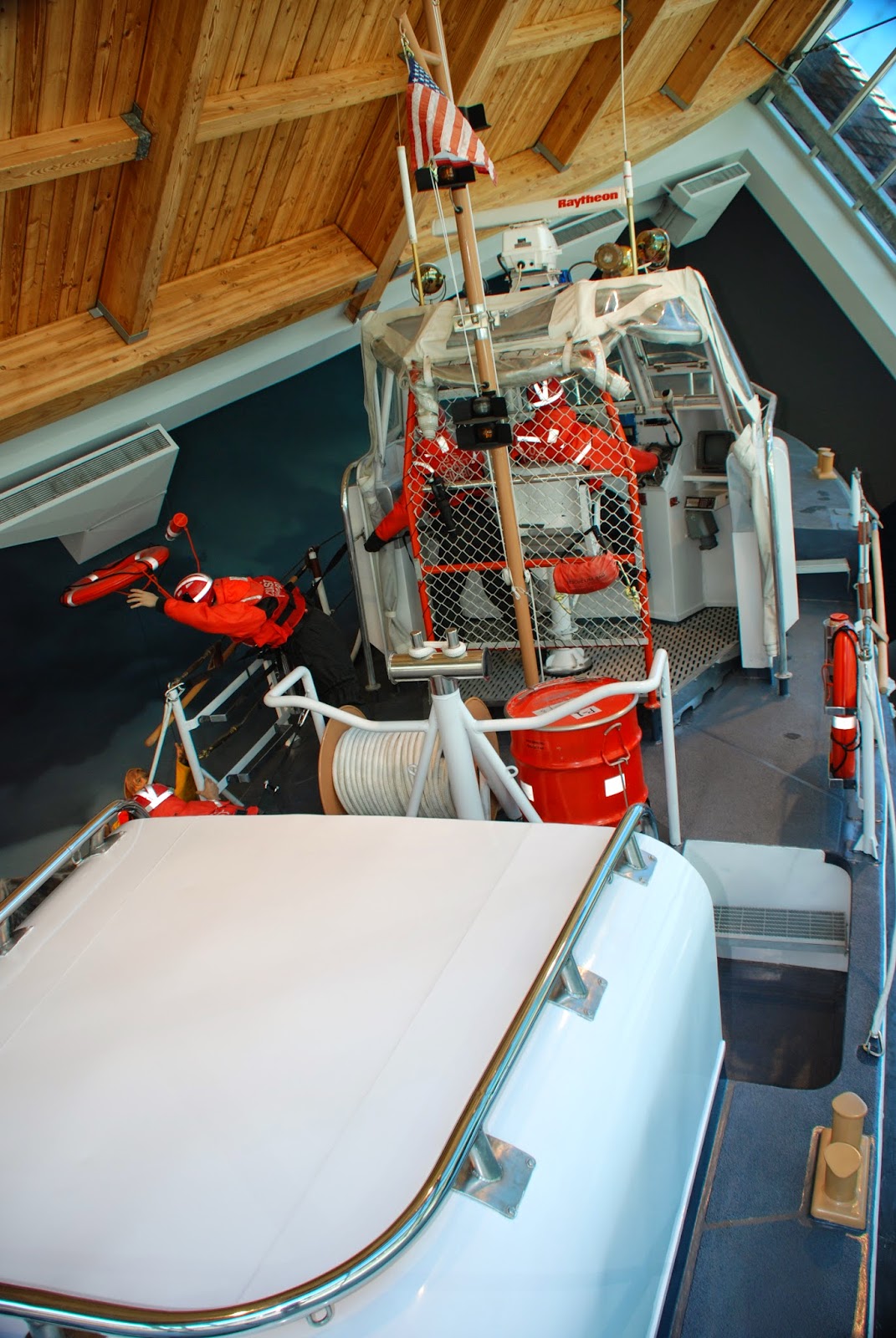


Cape Hatteras is the graveyard of the Atlantic
while the Columbia River bar is the graveyard of the Pacific!

Japanese boat washed ashore after the 2011 Tsunami.


This is the Astoria Column overlooking Astoria!
I have never seen anything like this!!!!!
The Astoria Column is a tower overlooking the mouth of the Columbia River on Coxcomb Hill in the city of Astoria in the U.S. state of Oregon. Built in 1926, the concrete and steel structure is part of a 30-acre city park. The 125-foot (38 m)-tall column has a 164-step spiral staircase ascending to an observation deck at the top and was added to the National Register of Historic Places on May 2, 1974. The tower was built in 1926 with financing by the Great Northern Railway and Vincent Astor, the great-grandson of John Jacob Astor, in commemoration of the city's role in the family's business history. Patterned after the Trajan Column in Rome, the Column was dedicated on July 22, 1926.
The 125-foot (38 m)-tall column stands atop 600-foot (180 m)-tall Coxcomb Hill and includes an interior spiral staircase that leads to an observation deck at the top. The spiral sgrafitto frieze on the exterior of the structure is almost seven feet wide, and 525 feet (160 m) long. Painted by Electus D. Litchfield and Attilio Pusterla, the mural shows 14 significant events in the early history of Oregon with a focus on Astoria's role including Captain Gray's discovery of the Columbia River in 1792 and the Lewis & Clark Expedition.


What detail!
And the view from on top!


And so goes another day!
And
The end of our Rivers West Tour!
Next
Calgary Stampede, Canadian Rockies
and
ALASKA!!
See You There!
and
ALASKA!!
See You There!