TOK, Alaska
Tok /ˈtoʊk/ is a census-designated place (CDP) in Southeast Fairbanks Census Area, Alaska, United States. The population was 1,258 at the 2010 census.History
The town at the present location of Tok began in 1942 as an Alaska Road Commission camp used for construction and maintenance of the Alaska Highway. So much money was spent in the camp's construction and maintenance that it earned the nickname "Million Dollar Camp" from those working on the highway. In 1947 the first school opened, and in 1958 a larger school was built to accommodate the many newcomers. In 1995 a new school was opened to provide for the larger community. A U.S. Customs Office was located in Tok between 1947 and 1971, when it was moved to the Canadian border.
In one version, the name Tok is derived from the Athabascan word for "peaceful crossing." The U.S. Geological Survey notes that the name "Tok River" was in use for the nearby river around 1901, and the Athabascan name of "Tokai" had been reported for the same river by Lt. Allen in 1887. In another version the name is derived from the English words "Tokyo camp", although the major war benefit was supporting the transfer of airplanes to the Soviet Union. Another version claims the name was derived from the canine mascot for one of the Engineer units that built the highways. The name has no connection to the western Alaskan community of Newtok.
In the 1940s and 1950s, another highway, the Tok Cut-Off was constructed and connected Tok with the Richardson Highway at Glennallen. It was a "cut-off" because it allowed motor travelers from the lower United States to travel to Valdez and Anchorage in south-central Alaska without going further north to Delta Junction and then traveling south on the Richardson Highway.
Between 1954 and 1979, an 8-inch U.S. Army fuel pipeline operated from the port of Haines to Fairbanks, with a pump station in Tok.
In July 1990 Tok faced extinction when a lightning-caused forest fire jumped two rivers and the Alaska Highway, putting both residents and buildings in peril. The town was evacuated and even the efforts of over a thousand firefighters could not stop the fire. At the last minute a "miracle wind" (so labeled by Tok's residents) came up, diverting the fire just short of the first building. The fire continued to burn the remainder of the summer, eventually burning more than 100,000 acres (400 km2).
On January 10, 2009, Tok made headlines with an unconfirmed temperature reading of −80 °F (−62 °C).
Getting The Top Of The World Highway Dirt Off
Time to Wash The RVs!!


Supervising??

With Two Lines - We Moved The RV's Through Quickly!


Everyone Chipped In And Helped!


And They Were Dirty!


With Clean RV's We Were Ready To Leave TOK
And Head Towards
Fairbanks!
On The Way
We Saw
The End of the Alcan Highway


We Made It!


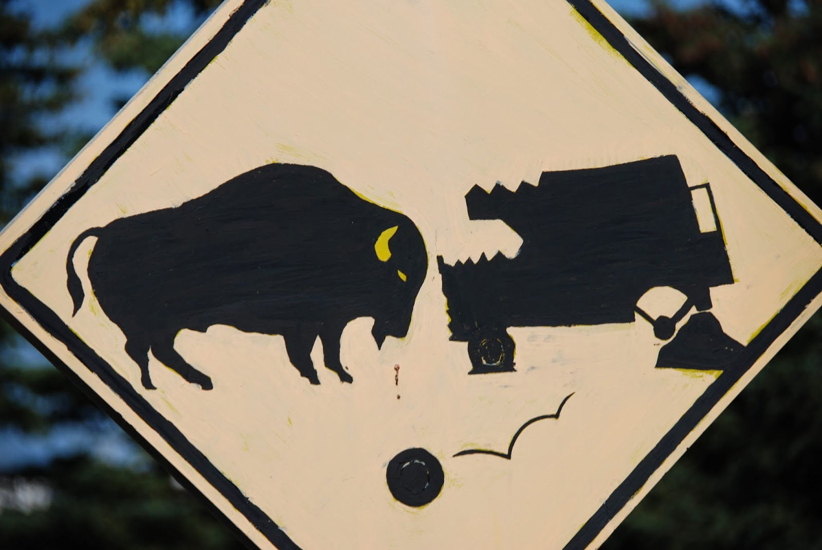
Unusual Bison Warning Sign!

We Saw Some Mosquitos!
Not Quite THIS Big!
But There Were Always
Sooo Many Flowers!


Pipeline Facts!
There are over 124,000 heat pipes along the pipeline. These pipes transfer ground heat into the air to ensure soil remains stable and able to support the pipeline.
Thickness of the pipeline wall: .462 inches (466 miles) & .562 inches (334 miles).
The Trans Alaska Pipeline System cross the ranges of the Central Arctic heard on the North Slope and the Nelchina Herd in the Copper River Basin.
The pipeline ends at the Valdez Marine Terminal.
The pipeline is often referred to as "TAPS" - an acronym for the Trans Alaska Pipeline System.
The Trans Alaska Pipeline System starts in Prudhoe Bay and stretches through rugged and beautiful terrain to Valdez, the northernmost ice-free point in America.
The Trans Alaska Pipeline System was designed and constructed to move oil from the North Slope of Alaska to the northern most ice-free port in Valdez, Alaska.
The Trans Alaska Pipeline System is protected by three separate leak detection systems that are monitored at the Operations Control Center in Anchorage.
Some 420 miles of the 800-mile-long pipeline is elevated on 78,000 vertical support members due to permafrost.
Telluric currents caused by the same phenomenon that generates the Northern Lights can be picked up by the pipeline and zinc/magnesium anodes. The anodes act like grounding rods to safety return these currents to the earth reducing the risk of damage to the pipeline.
The high point of the pipeline can be found at Atigun Pass with an elevation of 4,739 feet.
The Operations Control Center (OCC), located in Anchorage, monitors and controls pipeline and terminal operations 24/7.
Booster Pumps are located at all pump stations to move oil from the storage tanks to the mainline.
Cleaning pigs sweep the pipe of built up wax, water or other solids that precipitate out of the oil stream. They also prevent the built-up of corrosive environment and makes the oil easier to pump.
Controllers can stop pipeline flow within four minutes.
Crosses three mountain ranges and more than 30 major rivers and streams.
Grade, maximum: 145% (55%) at Thompson Pass.
Length: 800 miles.
Maximum daily throughput was 2,145,297 on January 14, 1988.
Miles of buried pipeline: 380.
More than 12,000 tankers have been escorted through Prince William Sound.
Almost 17 billion barrels have moved through TAPS.
More than 170 bird species have been identified along the trans-Alaska pipeline.
Mountain ranges crossed by the pipeline: Brooks Range, Alaska Range and Chugach Range.
Pig: A mechanical device that is pushed through the pipeline by the oil to perform various operations on the pipeline without stopping the flow of oil.
71 gate valves can block oil flow in either direction on the pipeline.
Air temperature along route: minus 80 F to 95 F.
All laden tankers are escorted more than 70 miles through the Prince William Sound into the Gulf of Alaska.
Average tanker turnaround time at the Valdez terminal is 22 hours and 20 minutes for berthing, offloading ballast, loading crude and deberthing.
SERVS (Ship Escort/Response Vessel System) exists to prevent oil spills by assisting tankers in safe navigation through Prince William Sound.
SERVS (Ship Escort/Response Vessel System) has contracted over 350 fishing vessels for incident response in Prince William Sound.
SERVS (Ship Escort/Response Vessel System) maintains one of the world's largest inventories of oil spill response equipment including more than 42 miles of boom and 100 skimmers, with a total recovery capacity of more than 75,000 barrels per hour.
The Valdez Terminal covers 1,000 acres and has facilities for crude oil metering, storage, transfer and loading.
The pipeline project involved some 70,000 workers from 1969 through 1977.
The first pipe of the Trans Alaska Pipeline System was laid in 1975.
Construction began March 27, 1975 and was completed May 31, 1977.
Construction Time: 3 years, 2 months.
OCC Controllers can stop pipeline flow within four minutes.
Cost to build: $8 billion in 1977, largest privately funded construction project at that time.
Diameter: 48 inches.
First oil moved through the pipeline on June 20, 1977.
First tanker to carry crude oil from Valdez: ARCO Juneau, August 1, 1977.
Alyeska Pipeline Service Company was established in 1970 to design, construct, operate and maintain the pipeline.
The Trans Alaska Pipeline System was originally designed with 12 pump stations, though it was decided that only 11 were needed and a 12th was never built.
Oil was first discovered in Prudhoe Bay on the North Slope in 1968.
Alyeska has slowed the amount of oil passing through the pipeline. As a result PIGs are used to remove wax buildup and keep the lines clear with the reduced flow rates.


Eielson Air Force Base

Eielson Air Force Base (AFB) (IATA: EIL, ICAO: PAEI, FAA LID: EIL) is a United States Air Force base located approximately 26 miles (42 km) southeast of Fairbanks, Alaska and just southeast of Moose Creek, Alaska.
The host unit at Eielson is the 354th Fighter Wing (354 FW) assigned to the Pacific Air Forces Eleventh Air Force. The 354 FW primary mission is to support Red Flag – Alaska, a series of Pacific Air Forces commander–directed field training exercises for U.S. Forces, provides joint offensive counter-air, interdiction, close-air support, and large force employment training in a simulated combat environment.
Until 2007, Eielson was a front line base, deploying fighter and bomber units around the world as well as providing for the defense of Alaska.
Taken off deployment status in 2007 as a result of BRAC 2005, today the primary mission of the base is to support Red Flag-Alaska, a series of Pacific Air Forces commander-directed field training exercises for U.S. Forces, provides joint offensive counter-air, interdiction, close-air support, and large force employment training in a simulated combat environment. These exercises are conducted on the Joint Pacific Alaskan Range complex with air operations flown out of the two bases. Alaska's size enables the military to have the largest air-ground training complex in America.
Eielson is home to the 354th Fighter Wing which is part of the Eleventh Air Force (11 AF) of Pacific Air Forces (PACAF). The 354th Fighter Wing mission is "To train, deliver, maintain and support combat power across the globe while taking care of our people, their families and our infrastructure." To accomplish that mission, the wing implements flying operations, mission support, maintenance and medical care functions and is host to 10 tenant units.
- 354th Operations Group (Tail Code: AK)
- 354th Operations Support Squadron
- 18th Aggressor Squadron (F-16)
- 3d Air Support Operations Squadron
- 353d Combat Training Squadron
- 354th Maintenance Group
- 354th Mission Support Group
- 354th Medical Group
- 354th Medical Operations Squadron
- 354th Medical Support Squadron
World War II
On 7 June 1943, the Western Defense Command ordered construction of a new airfield near present-day Fort Wainwright, then an Army airfield named after Major Arthur Ladd. Because of its hazard-free approaches and relatively flat terrain, surveyor reports indicated a site a little more than twenty five miles southeast of Ladd Army Airfield to be the best in the vicinity for military aviation. The field became known as "Mile 26" because of its proximity to a US Army Signal Corps telegraph station and a Richardson Highway milepost marker using the same designation.
A month later, contractors and civilian crews from Ladd Field started laying out the new airfield. Actual construction began on 25 August 1943. Crews built two parallel runways, 165 feet (50 m) across and 6,625 feet (2,019 m) long. Other facilities included an operations building, housing for 108 officer and 330 enlisted personnel, and a ten-bed dispensary. The garrison and airfield totaled about 600 acres (2.4 km2). Completed on 17 October 1944, the 14-month project cost about eight million dollars.
Operational uses of Mile 26 were few. Ladd Field served as the debarkation point for the Alaska-Siberia Ferry Route of the lend-lease program and was the hub of activity. Lend-lease aircraft would occasionally land at Mile 26, but there are no records to indicate any lend-lease aircraft ever used the airfield to take off for Russia. Mile 26 closed when the war ended.


Rika's Landing
Rika's Landing Roadhouse, also known as Rika's Landing Site or the McCarty Roadhouse, is a roadhouse located at a historically important crossing of the Tanana River, in the Southeast Fairbanks Area, Alaska, United States. It is off mile 274.5 of the Richardson Highway in Big Delta.
The roadhouse is named after Rika Wallen, who acquired it from John Hajdukovich and operated it for many years. It became a hub of activity in that region of the interior. With the construction of the ALCAN (now Alaska) Highway and the replacement of the ferry with a bridge downstream, traffic moved away and patronage declined. The roadhouse was added to the National Register of Historic Places in 1976, and is now a centerpiece of Big Delta State Historical Park, also listed on the National Register.
Background
Many roadhouses, some 37 in all and some now listed on the National Register of Historic Places, were built along this trail for the convenience of travelers. These roadhouses offered meals, sleeping quarters, and supplies. They were typically located about 15 to 20 miles apart.
Early activity
The Tanana River was one of the major rivers to be crossed by travelers along the Valdez-Eagle trail. A ferry was established just upriver of the Tanana's confluence with the Delta River, at a location then called Bates Landing. Bates Landing was about 12 km (7.5 mi) north of the current settlement of Delta Junction, in the area known now as Big Delta. The government collected a ferry toll on the south side from all those traveling northbound.The WAMCATS telegraph line was relocated to parallel the trail after a fire. McCarty Station was established at the line's crossing of the Tanana in 1907 to maintain the telegraph. Several log cabins housed the telegraph office, a dispatcher, two repairmen and their supplies.
A trading post was constructed on the south bank of the Tanana, at Bates Landing in April 1904 by a prospector named Ben Bennett on his claim of 80 acres (32 ha), but Bennett sold the post and land to Daniel G. McCarty in April 1905. However since E.T. Barnette, the founder of Fairbanks, and McCarty's former employer, had financed the goods in the post, Barnette retained ownership of them. The post property, now being used as a roadhouse, soon became known as McCarty's. Another prospector named Alonzo Maxey, and a friend, built Bradley's Roadhouse to compete with McCarty's and by 1907, McCarty's had been transferred to Maxey.


Rika


Finally Fairbanks, Alaska!
Alaska Salmon Bake!
Your salmon is fire cooked on our open wood grill while the Prime Rib is slow roasted as you watch with mouth-watering anticipation. Don't forget to try our Bering Sea Cod direct from icy Alaskan waters and beer battered to perfection as only our Alaskan chefs know how!
Lets Go Nancy
I'm Hungry!

It Was SOOO Good!!
There is also a museum here!

Old Shovel on Display!


Palace Theatre Show!
"The Golden Heart Revue" is a lighthearted, comic look at the colorful characters from early & present day Fairbanks. With the Fairbanks gold strike by Italian immigrant miner, Felix Pedro, in 1902, came the opportunists, homemakers and other seekers who built the town of Fairbanks on the banks of the Chena River in the very heart of the vast Alaskan wilderness.
And So Ends Another Day!
No comments:
Post a Comment